ArtsAutosBooksBusinessEducationEntertainmentFamilyFashionFoodGamesGenderHealthHolidaysHomeHubPagesPersonal FinancePetsPoliticsReligionSportsTechnologyTravel

San Bernardino Mountains Trip - With Pictures of Highway 18 Included.

Updated on September 8, 2016

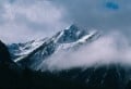
Walking in the San Bernardino Mountains can range from a simple stroll to extreme rock climbing, so the recreational choices are wuite unlimited. People who enjoy scaling rocks can do so out on the large boulder at The Pinnacles, but there is also a trail to the top for those who prefer less strenuous hikes. You can also walk on the paved streets up in the San Bernardino Mountains and still get quite a good work out, and witness the spectacular view of the trees around you. I would caution against going out by yourself in the wood though as I did encounter a bear once, and I also saw a mountain lion from a distance. I also saw a donkey and cows, but these animals actually seemed to be a bit more frightened of me than I ever was of them.

Spending a day in the San Bernardino Mountains is doable as it is only 80 miles east of Los Angeles, and you can use Google Earth to get directions there. Yes, I recommend Google Earth for driving directions as Mapquest has not mapped out some of the most rural areas of the San Bernardino Mountains. However, Google Earth has only mapped out the street view of major roads in the San Bernardino Mountains, but at least this tool provide detailed driving directions.

You can also take public transportation to the San Bernardino Mountains on MARTA, and there are many hotels and motels for lodging in the area. Actually, the San Bernardino Mountains have always catered to tourists, but you can only experience the true beauty of the mountain by going up there to see the scenery. Lake Arrowhead and Big Bear offer many wonderful restaurants and shops to check out when you are up there, but I also suggest you explore the hiking and walking the mountain has to offer. However, if you are not able to make a trip to the San Bernardino Mountains, then visiting my photo slide shows is definitely the next best thing!

Map of The San Bernardino Area

A
Lake Arrowhead Village:
Lake Arrowhead, CA, USA

get directions

The Scenery While Hiking and Walking Around The San Bernardino Mountains

The scenery is quite spectacular while walking around the San Bernardino Mountains.
The scenery is quite spectacular while walking around the San Bernardino Mountains. | Source
Here is a self-portrait I took of myself in the San Bernardino Mountains.
Here is a self-portrait I took of myself in the San Bernardino Mountains. | Source
Looking at a hillside in the San Bernardino Mountains.
Looking at a hillside in the San Bernardino Mountains. | Source
Picture of the beautiful clouds before a rainstorm that came that night.
Picture of the beautiful clouds before a rainstorm that came that night. | Source
I love the formation of the clouds above Mount Baldy.
I love the formation of the clouds above Mount Baldy. | Source
The shape of the mountains is always interesting to photograph.
The shape of the mountains is always interesting to photograph. | Source
I appreciate taking pictures of the view looking out towards Mount Baldy.
I appreciate taking pictures of the view looking out towards Mount Baldy. | Source
The tree next to the mountains in the distance makes this photograph awe inspiring.
The tree next to the mountains in the distance makes this photograph awe inspiring. | Source
Whenever I photograph Mount Baldy it is so hard to believe I have never been to Wrightwood, or scaled its peaks.  So close, yet so far away!
Whenever I photograph Mount Baldy it is so hard to believe I have never been to Wrightwood, or scaled its peaks. So close, yet so far away! | Source
Another scenic picture of Mount Baldy.
Another scenic picture of Mount Baldy. | Source
Looking down towards Hesperia in this photograph.
Looking down towards Hesperia in this photograph. | Source
The streaks of orange and blue in the sky near sunset.
The streaks of orange and blue in the sky near sunset. | Source
The trees are always enjoyable to photograph.
The trees are always enjoyable to photograph. | Source
I love the outline of the trees in the twilight of the day.
I love the outline of the trees in the twilight of the day. | Source
The silhouette of this tree is quite amazing near sunset.
The silhouette of this tree is quite amazing near sunset. | Source

When I take walks in the San Bernardino Mountains near twilight, I am often captivated by the beauty and the silhouettes creating by the forms of the mountains and the trees. Walking around the mountain is truly spectacular, and in the age of the digital camera there is no reason to keep me from taking as many glorious pictures as I see fit. I take more pictures than less because a few always end up being odd shots or a bit fuzzy, so having a variety to choose from is key. My pictures often later serve as inspiration for the sketches and the paintings I like to create.

Sunset Hour In The San Bernardino Mountains

The outline of this barren winter tree is quite interesting with the orange and blue colors of the sunset as a backdrop.
The outline of this barren winter tree is quite interesting with the orange and blue colors of the sunset as a backdrop. | Source
There is just something very beautiful about sunset photography.
There is just something very beautiful about sunset photography. | Source
A view of the mountains and the clouds at sunset.
A view of the mountains and the clouds at sunset. | Source
Streaks of brilliant color in the sky near sunset in the San Bernardino Mountains.
Streaks of brilliant color in the sky near sunset in the San Bernardino Mountains. | Source
Tinges of rosy colors in the the clouds above the San Bernardino Mountains.
Tinges of rosy colors in the the clouds above the San Bernardino Mountains. | Source

There is something magical about the vibrant sunsets of the San Bernardino Mountains that can make adults act like teenage couples. Seriously, one time I had to turn around when I was walking my dog up the street because there was a couple making out while they were enjoying the sunset, and I just felt very uncomfortable encroaching about their private moment, even if it was on a public street. Sometimes being in the mountains near sunset can make you forget about the rest of the world, which is a great thing if you are a couple just falling in love or rekindling the heat. Now if you are walking your dog and encounter such a couple, you might feel more comfortable walking along another street.

Pictures of Trees In The San Bernardino Mountains

Sunsety sky with Hesperia in the distance.
Sunsety sky with Hesperia in the distance. | Source
I love the silhouette of the tree on the left-hand side of this photograph.
I love the silhouette of the tree on the left-hand side of this photograph. | Source
The branches on the tree are very interesting in this photograph.
The branches on the tree are very interesting in this photograph. | Source
Love the pattern of the clouds in the sky here.
Love the pattern of the clouds in the sky here. | Source
The blue of the sky and the branches are the major details of this photograph.
The blue of the sky and the branches are the major details of this photograph. | Source
The pattern of the clouds in the sky near sunset.
The pattern of the clouds in the sky near sunset. | Source
Rain clouds near sunset in the San Bernardino Mountains.
Rain clouds near sunset in the San Bernardino Mountains. | Source
This picture was taken on a cold morning in late December in the San Bernardino Mountains.
This picture was taken on a cold morning in late December in the San Bernardino Mountains. | Source
The snow on Mount Baldy looks like frosting on a cake in this picture.  If I were a cake maker I would make a cake shaped like Mount Baldy.
The snow on Mount Baldy looks like frosting on a cake in this picture. If I were a cake maker I would make a cake shaped like Mount Baldy. | Source
I love the highest peak of the The Pinnalces, and the outline of this mountain range always conjures up thoughts of home.
I love the highest peak of the The Pinnalces, and the outline of this mountain range always conjures up thoughts of home. | Source
A black stump from the fire back in 2007.
A black stump from the fire back in 2007. | Source
Mount Baldy is quite spectacular from this angle, and the trees in the foreground are quite beautiful indeed.
Mount Baldy is quite spectacular from this angle, and the trees in the foreground are quite beautiful indeed. | Source
Looking down on a boulder below the road.
Looking down on a boulder below the road. | Source
Trees of many different varieties.
Trees of many different varieties. | Source
The view of The Pinnacles unobstructed.
The view of The Pinnacles unobstructed. | Source
Another view of The Pinnacles with trees off to the right-hand side of the photograph.
Another view of The Pinnacles with trees off to the right-hand side of the photograph. | Source

Taking pictures in the San Bernardino Mountains in late December is quite pleasurable, especially since there are so many interesting silhouettes of trees to photograph.  Some of the trees are dead due to the fire in 2007, but I truly believe these trees are still beautiful as these house many birds and squirrels.

Walking Around The San Bernardino Mountains In The Morning

Another fabulous view of Mount Baldy.
Another fabulous view of Mount Baldy. | Source
I enjoy taking pictures of Mount Baldy from different angles.  It is one of my favorite locales to photograph when I am up in the San Bernardino Mountains.  Also, I appreciate how the trees in the foreground add to the beauty of this image.
I enjoy taking pictures of Mount Baldy from different angles. It is one of my favorite locales to photograph when I am up in the San Bernardino Mountains. Also, I appreciate how the trees in the foreground add to the beauty of this image. | Source
The dead tree in this picture is truly beautiful, and it is a home to many birds and squirrels.
The dead tree in this picture is truly beautiful, and it is a home to many birds and squirrels. | Source
The orange post makes an interesting focal point in this picture.
The orange post makes an interesting focal point in this picture. | Source
All the beautiful sights to see while walking around the San Bernardino Mountains.
All the beautiful sights to see while walking around the San Bernardino Mountains. | Source
Another view looking down towards Hesperia with trees framing the photograph.
Another view looking down towards Hesperia with trees framing the photograph. | Source
Looking at the mountains is quite a treat.
Looking at the mountains is quite a treat. | Source
A beautiful pine tree off the left-hand side of this photograph.
A beautiful pine tree off the left-hand side of this photograph. | Source
Looking out across the mountains.
Looking out across the mountains. | Source
Verdant trees in the San Bernardino Mountains.
Verdant trees in the San Bernardino Mountains. | Source
Looking up at the glorious hillside.
Looking up at the glorious hillside. | Source
A serene pine tree in the San Bernardino Mountains.
A serene pine tree in the San Bernardino Mountains. | Source
Looking at all the beautiful trees on the hillside.
Looking at all the beautiful trees on the hillside. | Source

Talking Pictures As I Walk Around The San Bernardino Mountains

Looking at the magnificent view as I talk a walk on the backside of the San Bernardino Mountains.
Looking at the magnificent view as I talk a walk on the backside of the San Bernardino Mountains. | Source
A tree trunk as photographed on my walk in the San Bernardino Mountains.
A tree trunk as photographed on my walk in the San Bernardino Mountains. | Source
A bright green baby cedar tree in the San Bernardino Mountains.
A bright green baby cedar tree in the San Bernardino Mountains. | Source
I love this small little cedar tree, and may one day draw it.
I love this small little cedar tree, and may one day draw it. | Source
I decided to take some spectacular pictures of the view from the Rim of the World Highway, but I would not really recommend walking on it.  Some people bike down it, but they are far braver than I could ever be.
I decided to take some spectacular pictures of the view from the Rim of the World Highway, but I would not really recommend walking on it. Some people bike down it, but they are far braver than I could ever be. | Source
Trees and clouds as seen from the Rim of the World Highway.
Trees and clouds as seen from the Rim of the World Highway. | Source
Here I stopped and walked around a bit to get some more spectacular views as seen from the Rim of the World Highway.
Here I stopped and walked around a bit to get some more spectacular views as seen from the Rim of the World Highway. | Source
View of some beautiful boulders on the Rim of the World Highway.
View of some beautiful boulders on the Rim of the World Highway. | Source
Amazing clouds as seen from Highway 18 in the San Bernardino Mountains.
Amazing clouds as seen from Highway 18 in the San Bernardino Mountains. | Source
Another beautiful view of the San Bernardino Mountains.
Another beautiful view of the San Bernardino Mountains. | Source
Clouds floating above the San Bernardino Valley.
Clouds floating above the San Bernardino Valley. | Source
A view of Mount San Gorgonio as seen from the San Bernardino Mountains.
A view of Mount San Gorgonio as seen from the San Bernardino Mountains. | Source
The view of the clouds below the San Bernardino Mountains.
The view of the clouds below the San Bernardino Mountains. | Source
Verdent canyon as seen from Highway 18 in the San Bernardino Mountains.
Verdent canyon as seen from Highway 18 in the San Bernardino Mountains. | Source
Another view of the verdent canyon as seen from Highway 18.
Another view of the verdent canyon as seen from Highway 18. | Source

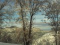
The diligent reader have noticed that some of the pictures I have taken on the Rim of the World of the Highway are not really ones you would want to take on a walk, but I just had to include this beautiful scenery on the hub so you could see what the San Bernardino Mountains really look like. I believe these pictures give a good depiction of what the mountain looks like when traveling down the Rim of the World Highway.

Pictures of The Beautiful View From The Rim of The World Highway

Clouds floating over the San Bernardino Valley.  This picture was taken while traveling up the Rim of the World Highway.
Clouds floating over the San Bernardino Valley. This picture was taken while traveling up the Rim of the World Highway. | Source
Another picture I took as traveling up Highway 18 looking down on the valley below.
Another picture I took as traveling up Highway 18 looking down on the valley below. | Source
The outline of a magnificent tree as seen from Highway 18 in the San Bernardino Mountains
The outline of a magnificent tree as seen from Highway 18 in the San Bernardino Mountains | Source
A beautiful tree trunk as seen on the journey up Highway 18.
A beautiful tree trunk as seen on the journey up Highway 18. | Source

Even if you are driving up or down the Rim of the World Highway, I highly recommend stopping at one of the turnouts so you can partake of the magnificent view.

Pictures On Highway 18 In Skyforest

Here I got out on one of the turnouts on Highway 18 to take this picture in Skyforest, which was the location of the old Santa's Village amusement park.
Here I got out on one of the turnouts on Highway 18 to take this picture in Skyforest, which was the location of the old Santa's Village amusement park. | Source
The trees below look very inviting.
The trees below look very inviting. | Source
A tall evergreen tree as seen from Highway 18.
A tall evergreen tree as seen from Highway 18. | Source
Green trees are quite beautiful look at while walking around a turnout in Skyforest, California, which is in the San Bernardino Mountains.
Green trees are quite beautiful look at while walking around a turnout in Skyforest, California, which is in the San Bernardino Mountains. | Source
The view of a tree from the Rim of the World Highway.
The view of a tree from the Rim of the World Highway. | Source

Beautiful Pictures From Highway 18 In The San Bernardino Mountains

Beautiful evergreen trees as seen from the Rim of the World of Highway.
Beautiful evergreen trees as seen from the Rim of the World of Highway. | Source
A picture of another beautiful evergreen tree in the San Bernardino Mountains.
A picture of another beautiful evergreen tree in the San Bernardino Mountains. | Source
I love how the image of the valley below can been seen throw the thin portions of the focal tree in this picture.
I love how the image of the valley below can been seen throw the thin portions of the focal tree in this picture. | Source
The view of the San Bernardino Valley as seen driving down the mountain.
The view of the San Bernardino Valley as seen driving down the mountain. | Source
I love the swirly clouds seen below Highway 18.
I love the swirly clouds seen below Highway 18. | Source

It is enjoyable to take pictures of all the beautiful scenery on the drive down Highway 18, and many turn out quite well even though I was in a moving vehicle when I took these photographs.

Pictures From The Trip Down The Rim of The World Highway

Picture of a pine tree on the way down the mountain.
Picture of a pine tree on the way down the mountain. | Source
Picture of an oak tree on the way down Highway 18.
Picture of an oak tree on the way down Highway 18. | Source
A picture taken on the drive down Highway 18.
A picture taken on the drive down Highway 18. | Source
Looking up at a stellar pine tree.
Looking up at a stellar pine tree. | Source
The spectacular view on the way down Highway 18.
The spectacular view on the way down Highway 18. | Source
Statuesque trees on a hillside above Highway 18.
Statuesque trees on a hillside above Highway 18. | Source
Looking up at evergreen trees while in the San Bernardino Mountains.
Looking up at evergreen trees while in the San Bernardino Mountains. | Source
I used photo editing software to take a dim photograph and turn it into something visually interesting.  Trees as seen on the drive down the Rim of the World Highway.
I used photo editing software to take a dim photograph and turn it into something visually interesting. Trees as seen on the drive down the Rim of the World Highway. | Source
I used photo editing software to zoom in on a small patch of evergreen trees that I photographed on Highway 18.
I used photo editing software to zoom in on a small patch of evergreen trees that I photographed on Highway 18. | Source
Rocks and brush on the cliff above Highway 18.
Rocks and brush on the cliff above Highway 18. | Source
I like the reflection on the window of the valley below as I take a picture of the rocky cliffs on the way down Highway 18.  To me, this blurry photograph has many artistic qualities.
I like the reflection on the window of the valley below as I take a picture of the rocky cliffs on the way down Highway 18. To me, this blurry photograph has many artistic qualities. | Source
A chaparral bush as seen on the drive down Highway 18.
A chaparral bush as seen on the drive down Highway 18. | Source
The rocks are kept from sliding down Highway 18 with nets on various portions on the cliff.  These are quite interesting to see on the drive down the mountain.
The rocks are kept from sliding down Highway 18 with nets on various portions on the cliff. These are quite interesting to see on the drive down the mountain. | Source

I always enjoy all the different rocks and vegetation I spot on the hillsides during the drive down Highway 18. That is one of the perks of not driving; being able to take really great photos.

Rocks, Trees, And Bushes On Highway 18

Rocks and brush on Highway 18.
Rocks and brush on Highway 18. | Source
View of the rocks on the right side of the road on the drive down Highway 18.
View of the rocks on the right side of the road on the drive down Highway 18. | Source
Cliff on Highway 18.
Cliff on Highway 18. | Source
View of the rocks and the bushes on the side of the cliff above Highway 18.
View of the rocks and the bushes on the side of the cliff above Highway 18. | Source
Looking at the vegetation on the hills above Highway 18.
Rocks often roll down the cliffs on the right side of Highway 18.  Nets are used on parts of the highway to keep the larger rocks from rolling down onto the road.
Rocks often roll down the cliffs on the right side of Highway 18. Nets are used on parts of the highway to keep the larger rocks from rolling down onto the road. | Source
Bushes and boulders on the hillside.
Bushes and boulders on the hillside. | Source
A picture of the top half of the Crestline sign on the way down Highway 18.  I was not trying to take a picture of the sign, but it ended up in one of the numerous photos I was taking from the backseat of the car.
A picture of the top half of the Crestline sign on the way down Highway 18. I was not trying to take a picture of the sign, but it ended up in one of the numerous photos I was taking from the backseat of the car. | Source
The spectacular view from Highway 18.  These photographs turned out pretty well since I was taking these from the back seat of a moving car.
The spectacular view from Highway 18. These photographs turned out pretty well since I was taking these from the back seat of a moving car. | Source
A verdant bush on the way down Highway 18.
A verdant bush on the way down Highway 18. | Source
A stop sign near one of the turnouts on Highway 18.  If you pull into this turnout it is very spectacular with the view of the canyon above it.
A stop sign near one of the turnouts on Highway 18. If you pull into this turnout it is very spectacular with the view of the canyon above it. | Source
More rocks and boulders on Highway 18.
More rocks and boulders on Highway 18. | Source
A curve in the road on the way down Highway 18.
A curve in the road on the way down Highway 18. | Source
The magnificent rocky cliff above the Rim of the World Highway.
The magnificent rocky cliff above the Rim of the World Highway. | Source
Looking up at the trees on Highway 18.
Looking up at the trees on Highway 18. | Source

Every time experience the view on the ride down the San Bernardino Mountains, I am reminded of the beauty of the cliff and vistas as seen from this scenic route.

Pictures Near The Bottom of The Rim of The World Highway

Looking up the cliff from Highway 18.
Looking up the cliff from Highway 18. | Source
Green vegetation on the hillside above Highway 18.
Green vegetation on the hillside above Highway 18. | Source
Beautiful picture of a tree in the San Bernardino Mountains.
Beautiful picture of a tree in the San Bernardino Mountains. | Source
A cliff above Highway 18 with many interesting rocks and bushes.  A net is used to keep the rocks from sliding off the hillside.
A cliff above Highway 18 with many interesting rocks and bushes. A net is used to keep the rocks from sliding off the hillside. | Source
A yucca on the hillside on the way down Highway 18.
A yucca on the hillside on the way down Highway 18. | Source
Signs reminding people only drive thirty miles per hour around the curves on Highway 18.
Signs reminding people only drive thirty miles per hour around the curves on Highway 18. | Source

Towards The Bottom of Highway 18

Blue sky on the way down the mountain.
Blue sky on the way down the mountain. | Source
The point of a hill.
The point of a hill. | Source
Blue sky and hills as seen from Highway 18.
Blue sky and hills as seen from Highway 18. | Source
Rocky hillside wushing by on the ride down Highway 18.
The bright blue sky with rays of sun.
The bright blue sky with rays of sun. | Source
Blue sky with brush towards the bottom of the photograph.
Blue sky with brush towards the bottom of the photograph. | Source
Down in the San Bernardino Valley, but I love the palms in this photo.
Down in the San Bernardino Valley, but I love the palms in this photo. | Source
More palms and trees in the San Bernardino Valley.
More palms and trees in the San Bernardino Valley. | Source
Picture of Mount San Gorgonio from the San Bernardino Valley.
Picture of Mount San Gorgonio from the San Bernardino Valley. | Source
Another view of Mount San Gorgonio surrounded by wispy clouds.  It rained considerably the next few days after this picture was taken.
Another view of Mount San Gorgonio surrounded by wispy clouds. It rained considerably the next few days after this picture was taken. | Source

Have you ever walked or hiked around the San Bernardino Mountains?

See results
working

This website uses cookies

As a user in the EEA, your approval is needed on a few things. To provide a better website experience, hubpages.com uses cookies (and other similar technologies) and may collect, process, and share personal data. Please choose which areas of our service you consent to our doing so.

For more information on managing or withdrawing consents and how we handle data, visit our Privacy Policy at: https://corp.maven.io/privacy-policy

Show Details
Necessary
HubPages Device IDThis is used to identify particular browsers or devices when the access the service, and is used for security reasons.
LoginThis is necessary to sign in to the HubPages Service.
Google RecaptchaThis is used to prevent bots and spam. (Privacy Policy)
AkismetThis is used to detect comment spam. (Privacy Policy)
HubPages Google AnalyticsThis is used to provide data on traffic to our website, all personally identifyable data is anonymized. (Privacy Policy)
HubPages Traffic PixelThis is used to collect data on traffic to articles and other pages on our site. Unless you are signed in to a HubPages account, all personally identifiable information is anonymized.
Amazon Web ServicesThis is a cloud services platform that we used to host our service. (Privacy Policy)
CloudflareThis is a cloud CDN service that we use to efficiently deliver files required for our service to operate such as javascript, cascading style sheets, images, and videos. (Privacy Policy)
Google Hosted LibrariesJavascript software libraries such as jQuery are loaded at endpoints on the googleapis.com or gstatic.com domains, for performance and efficiency reasons. (Privacy Policy)
Features
Google Custom SearchThis is feature allows you to search the site. (Privacy Policy)
Google MapsSome articles have Google Maps embedded in them. (Privacy Policy)
Google ChartsThis is used to display charts and graphs on articles and the author center. (Privacy Policy)
Google AdSense Host APIThis service allows you to sign up for or associate a Google AdSense account with HubPages, so that you can earn money from ads on your articles. No data is shared unless you engage with this feature. (Privacy Policy)
Google YouTubeSome articles have YouTube videos embedded in them. (Privacy Policy)
VimeoSome articles have Vimeo videos embedded in them. (Privacy Policy)
PaypalThis is used for a registered author who enrolls in the HubPages Earnings program and requests to be paid via PayPal. No data is shared with Paypal unless you engage with this feature. (Privacy Policy)
Facebook LoginYou can use this to streamline signing up for, or signing in to your Hubpages account. No data is shared with Facebook unless you engage with this feature. (Privacy Policy)
MavenThis supports the Maven widget and search functionality. (Privacy Policy)
Marketing
Google AdSenseThis is an ad network. (Privacy Policy)
Google DoubleClickGoogle provides ad serving technology and runs an ad network. (Privacy Policy)
Index ExchangeThis is an ad network. (Privacy Policy)
SovrnThis is an ad network. (Privacy Policy)
Facebook AdsThis is an ad network. (Privacy Policy)
Amazon Unified Ad MarketplaceThis is an ad network. (Privacy Policy)
AppNexusThis is an ad network. (Privacy Policy)
OpenxThis is an ad network. (Privacy Policy)
Rubicon ProjectThis is an ad network. (Privacy Policy)
TripleLiftThis is an ad network. (Privacy Policy)
Say MediaWe partner with Say Media to deliver ad campaigns on our sites. (Privacy Policy)
Remarketing PixelsWe may use remarketing pixels from advertising networks such as Google AdWords, Bing Ads, and Facebook in order to advertise the HubPages Service to people that have visited our sites.
Conversion Tracking PixelsWe may use conversion tracking pixels from advertising networks such as Google AdWords, Bing Ads, and Facebook in order to identify when an advertisement has successfully resulted in the desired action, such as signing up for the HubPages Service or publishing an article on the HubPages Service.
Statistics
Author Google AnalyticsThis is used to provide traffic data and reports to the authors of articles on the HubPages Service. (Privacy Policy)
ComscoreComScore is a media measurement and analytics company providing marketing data and analytics to enterprises, media and advertising agencies, and publishers. Non-consent will result in ComScore only processing obfuscated personal data. (Privacy Policy)
Amazon Tracking PixelSome articles display amazon products as part of the Amazon Affiliate program, this pixel provides traffic statistics for those products (Privacy Policy)
ClickscoThis is a data management platform studying reader behavior (Privacy Policy)